Skip to content
  • Home
  • Choose A State
    • Alabama
    • Alaska
    • Arizona
    • Arkansas
    • California
    • Colorado
    • Connecticut
    • Delaware
    • Florida
    • Georgia
    • Hawaii
    • Idaho
    • Illinois
    • Indiana
    • Iowa
    • Kansas
    • Kentucky
    • Louisiana
    • Maine
    • Maryland
    • Massachusetts
    • Michigan
    • Minnesota
    • Mississippi
    • Missouri
    • Montana
    • Nebraska
    • Nevada
    • New Hampshire
    • New Jersey
    • New Mexico
    • New York
    • North Carolina
    • North Dakota
    • Ohio
    • Oklahoma
    • Oregon
    • Pennsylvania
    • Rhode Island
    • South Carolina
    • South Dakota
    • Tennessee
    • Texas
    • Utah
    • Vermont
    • Virginia
    • Washington
    • Washington, DC
    • West Virginia
    • Wisconsin
    • Wyoming
    • USA Maps
  • Choose A Category
    • US Regional Maps
    • USA Maps
    • Educational Maps
      • US, World & Continents Combo Pull Down Maps
    • Topographic Maps
      • Any USA Topographic Map
      • Alabama Topographic Maps
      • Arizona Topographic Maps
      • Arkansas Topographic Maps
      • California Topographic Maps
      • Colorado Topographic Maps
      • Delaware Topographic Maps
      • Florida Topographic Maps
      • Georgia Topographic Maps
      • Hawaii Topographic Maps
      • Idaho Topographic Maps
      • Illinois Topographic Maps
      • Indiana Topogrpahic Maps
      • Iowa Topographic Maps
      • Kansas Topographic Maps
      • Kentucky Topographic Maps
      • Louisiana Topographic Maps
      • Maine Topographic Maps
      • Maryland Topographic Maps
      • Massachusetts Topographic Maps
      • Michigan Topographic Maps
      • Minnesota Topographic Maps
      • Mississippi Topographic Maps
      • Missouri Topographic Maps
      • Montana Topographic Maps
      • Nebraska Topographic Maps
      • Nevada Topographic Maps
      • New Hampshire Topographic Maps
      • New Jersey Topographic Maps
      • New Mexico Topographic Maps
      • New York Topographic Maps
      • North Carolina Topographic Maps
      • North Dakota Topographic Maps
      • Ohio Topographic Maps
      • Oklahoma Topographic Maps
      • Oregon Topographic Maps
      • Pennsylvania Topographic Maps
      • Rhode Island Topographic Maps
      • South Carolina Topographic Maps
      • South Dakota Topographic Maps
      • Tennessee Topographic Maps
      • Texas Topographic Maps
      • Utah Topographic Maps
      • Vermont Topographic Maps
      • Virginia Topographic Maps
      • Washington Topographic Maps
      • West Virginia Topographic Maps
      • Wisconsin Topographic Maps
      • Wyoming Topographic Maps
    • World Wall Maps
    • International Maps
    • War Maps
  • Helpful Info
    • Our Printing Process
    • Shipping
    • Returns
    • Purchase Orders
    • Custom Maps
  • Log in
Cart
American Map Store American Map Store
Log in Search Cart
Home / Minnesota: Wall Maps / Minnesota

Minnesota: Wall Maps

Minnesota: Wall Maps

  • View all
  • Minnesota
  • Minnesota: Wall Maps
Quick view
Minnesota Wall Map by Globe Turner
from $54.95
Quick view
Minnesota State Wall Map
from $69.95
Quick view
Color Cast Style Wall Map of Minnesota by Market Maps
from $118.75
Quick view
Colorcast Zip Code Style Wall Map of St. Paul, MN. by Market Maps
from $118.75
Quick view
Colorcast Zip Code Style Wall Map of Minneapolis, MN. by Market Maps
from $118.75
Quick view
Premium Style Wall Map of Minneapolis, MN. by Market Maps
from $118.75
Quick view
Premium Style Wall Map of St. Paul, MN. by Market Maps
from $118.75
Quick view
Premium Style Wall Map of Minnesota by Market Maps
from $118.75
Quick view
Minnesota Zip Code Map
from $64.95
Quick view
Minnesota by Rand McNally
$229.00
Minnesota Wall Map by Globe Turner

Minnesota Wall Map by Globe Turner

MNWM002

Regular price $54.95

This colorful, easy-to-read state map of Minnesota identifies all major thoroughfares, secondary roads, freeway interchanges, rest areas, distance markers, landmarks, recreational areas, and more. Shaded relief on the state map provides a three-dimensional sense of Minnesota's topography. Detailed city inset maps of Duluth, Rochester and the Twin Cities are based on the latest street information from our cartographic experts. Up-to-date insets of downtown Minneapolis and downtown St. Paul are included as well. County and city indices make it simple to locate even the smallest town.

This map is rolled and shipped in a sturdy cardboard tube.

Minnesota State Wall Map

Minnesota State Wall Map

MNWM005

Regular price $69.95
Wall map of Minnesota, showing counties, towns, cities, villages, major roads and highways. A community index is included.

This map comes in a variety of sizes and finishing options. It is shipped rolled in a sturdy cardboard tube.

Color Cast Style Wall Map of Minnesota by Market Maps

Color Cast Style Wall Map of Minnesota by Market Maps

MNWM004CC-1

Regular price $118.75

The Color Cast Style Iowa State Map is a multi-colored display that shades each county with its own background color. It is an ideal choice for applications that benefit from quickly and easily distinguishing one county from the others. 

This wall map comes laminated on both sides using 3mm hot lamination, which protects your wall map and allows you to write on it with dry-erase markers.

Includes inset maps of all major cities.

Features include:

  • Cities and Towns
  • Interstate/Us/State Highways
  • Color Coded & Labeled Counties
  • 5-Digit ZIP Codes Labeled with Boundaries
  • Fully Indexed Cities, Towns and Zip Codes

This map is rolled and shipped in a sturdy cardboard tube.

Colorcast Zip Code Style Wall Map of St. Paul, MN. by Market Maps

Colorcast Zip Code Style Wall Map of St. Paul, MN. by Market Maps

MNWM100CC-1

Regular price $118.75

Save money on our full line of wall maps from one of the industry leaders in wall maps. These always up to date, eye catching wall maps come in a variety of sizes and finishing options sure to meet your specific mapping needs.

Features include:

  • Interstate/Us/State Highways
  • 5-Digit ZIP Codes
  • County Names and boundaries
  • Cities and Towns as applicable
  • All water
  • ZIP Code index with grid locator

    Note: Major streets & highways available in all sizes. All streets & highways only available in larger sizes and will show unavailable in smaller sizes.

    This map is rolled and shipped in a sturdy cardboard tube.

    Colorcast Zip Code Style Wall Map of Minneapolis, MN. by Market Maps
    Colorcast Zip Code Style Wall Map of Minneapolis, MN. by Market Maps
    Colorcast Zip Code Style Wall Map of Minneapolis, MN. by Market Maps
    Colorcast Zip Code Style Wall Map of Minneapolis, MN. by Market Maps
    Colorcast Zip Code Style Wall Map of Minneapolis, MN. by Market Maps
    Colorcast Zip Code Style Wall Map of Minneapolis, MN. by Market Maps
    Colorcast Zip Code Style Wall Map of Minneapolis, MN. by Market Maps
    Colorcast Zip Code Style Wall Map of Minneapolis, MN. by Market Maps

    Colorcast Zip Code Style Wall Map of Minneapolis, MN. by Market Maps

    MNWM101CC-1

    Regular price $118.75

    Save money on our full line of wall maps from one of the industry leaders in wall maps. These always up to date, eye catching wall maps come in a variety of sizes and finishing options sure to meet your specific mapping needs.

    Features include:

    • Interstate/Us/State Highways
    • 5-Digit ZIP Codes
    • County Names and boundaries
    • Cities and Towns as applicable
    • All water
    • ZIP Code index with grid locator

      Note: Major streets & highways available in all sizes. All streets & highways only available in larger sizes and will show unavailable in smaller sizes.

      This map is rolled and shipped in a sturdy cardboard tube.

      Premium Style Wall Map of Minneapolis, MN. by Market Maps
      Premium Style Wall Map of Minneapolis, MN. by Market Maps
      Premium Style Wall Map of Minneapolis, MN. by Market Maps
      Premium Style Wall Map of Minneapolis, MN. by Market Maps
      Premium Style Wall Map of Minneapolis, MN. by Market Maps
      Premium Style Wall Map of Minneapolis, MN. by Market Maps

      Premium Style Wall Map of Minneapolis, MN. by Market Maps

      MNWM101-1

      Regular price $118.75

      Save money on our full line of wall maps from one of the industry leaders in wall maps. These always up to date, eye catching wall maps come in a variety of sizes and finishing options sure to meet your specific mapping needs.

      Features include:

      • Interstate/Us/State Highways
      • 5-Digit ZIP Codes
      • County Names and boundaries
      • Cities and Towns as applicable
      • All water
      • Institutions
      • Cemetery
      • Airports
      • Golf Courses
      • Parks
      • Populated Places Shaded
      • ZIP Code index with grid locator

      Note: Major streets & highways available in all sizes. All streets & highways only available in larger sizes and will show unavailable in smaller sizes.

      This map is rolled and shipped in a sturdy cardboard tube.

      Premium Style Wall Map of St. Paul, MN. by Market Maps
      Premium Style Wall Map of St. Paul, MN. by Market Maps
      Premium Style Wall Map of St. Paul, MN. by Market Maps
      Premium Style Wall Map of St. Paul, MN. by Market Maps
      Premium Style Wall Map of St. Paul, MN. by Market Maps
      Premium Style Wall Map of St. Paul, MN. by Market Maps

      Premium Style Wall Map of St. Paul, MN. by Market Maps

      MNWM100-1

      Regular price $118.75

      Save money on our full line of wall maps from one of the industry leaders in wall maps. These always up to date, eye catching wall maps come in a variety of sizes and finishing options sure to meet your specific mapping needs.

      Features include:

      • Interstate/Us/State Highways
      • 5-Digit ZIP Codes
      • County Names and boundaries
      • Cities and Towns as applicable
      • All water
      • Institutions
      • Cemetery
      • Airports
      • Golf Courses
      • Parks
      • Populated Places Shaded
      • ZIP Code index with grid locator

      Note: Major streets & highways available in all sizes. All streets & highways only available in larger sizes and will show unavailable in smaller sizes.

      This map is rolled and shipped in a sturdy cardboard tube.

      Premium Style Wall Map of Minnesota by Market Maps
      Premium Style Wall Map of Minnesota by Market Maps
      Premium Style Wall Map of Minnesota by Market Maps
      Premium Style Wall Map of Minnesota by Market Maps
      Premium Style Wall Map of Minnesota by Market Maps
      Premium Style Wall Map of Minnesota by Market Maps
      Premium Style Wall Map of Minnesota by Market Maps
      Premium Style Wall Map of Minnesota by Market Maps

      Premium Style Wall Map of Minnesota by Market Maps

      MNWM004-1

      Regular price $118.75

      Save money on our full line of wall maps from one of the industry leaders in wall maps. These always up to date, eye catching wall maps come in a variety of sizes and finishing options sure to meet your specific mapping needs.

      Features include:

      • Interstate/Us/State Highways
      • 5-Digit ZIP Codes
      • County Names and boundaries
      • Cities and Towns as applicable
      • All water
      • Institutions
      • Cemetery
      • Airports
      • Golf Courses
      • Parks
      • Populated Places Shaded
      • ZIP Code index with grid locator

      This map is rolled and shipped in a sturdy cardboard tube.


      Minnesota Zip Code Map
      Minnesota Zip Code Map

      Minnesota Zip Code Map

      MNWM003

      Regular price $64.95

      This map of Minnesota shows ZIP codes overlaid on a road map. Base map features include county boundaries, major road network features, and state and national parks and conservation areas.

      This map is rolled and shipped in a sturdy cardboard tube.

      Minnesota by Rand McNally
      Minnesota by Rand McNally
      Minnesota by Rand McNally
      Minnesota by Rand McNally
      Minnesota by Rand McNally
      Minnesota by Rand McNally

      Minnesota by Rand McNally

      MNWM001

      Regular price $229.00
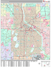
      • Laminated with Hanging Rails
      • 46" W x 60" H
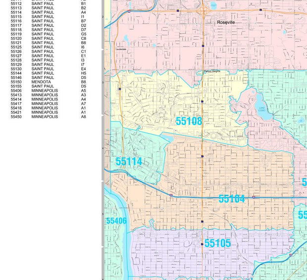
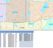
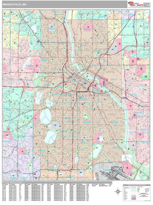
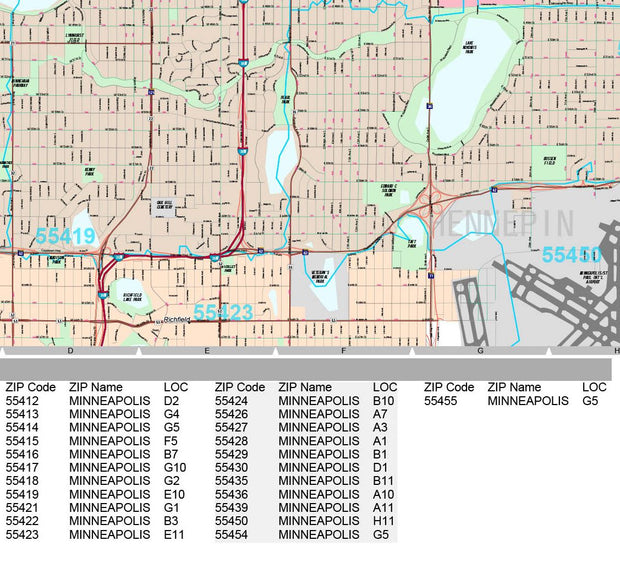
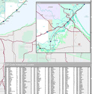
      • Index of Counties and Cities
      • Fully Indexed Counties, Cities, Mileage Chart
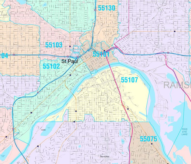
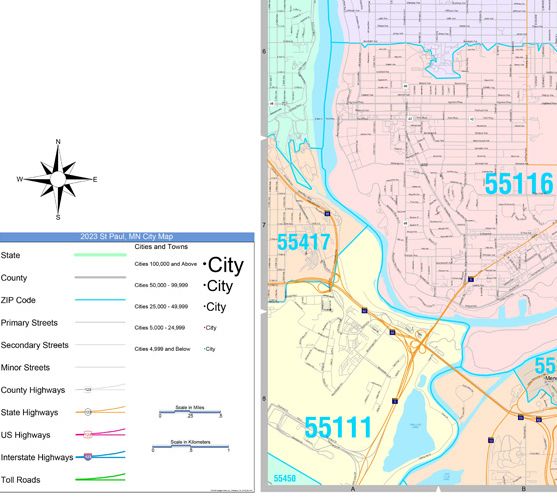
      • Inset Maps of All Major Cities
      • Free Shipping!

      Description  

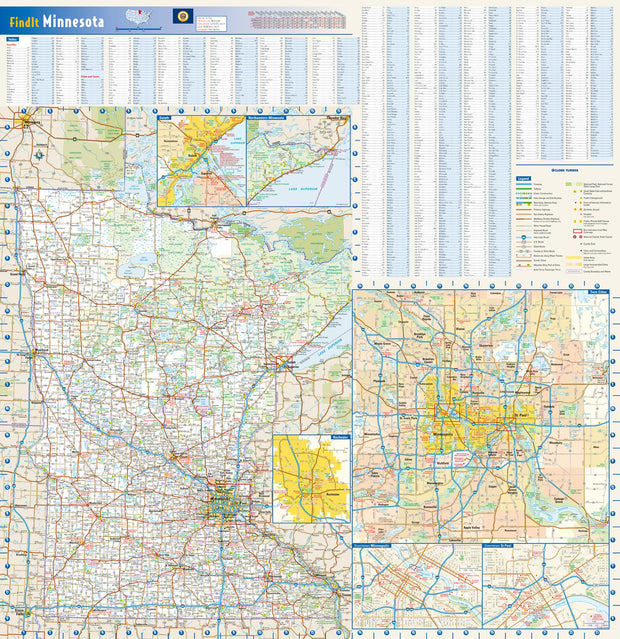
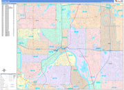
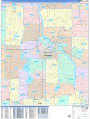
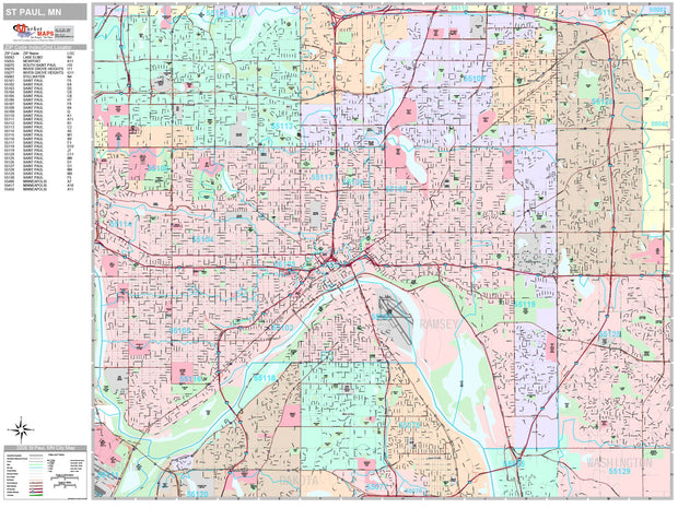
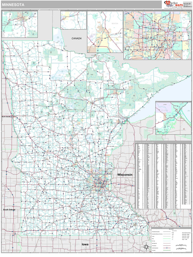
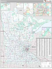
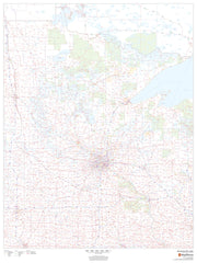
      Rand McNally's state wall map of Minnesota is ideal for anyone needing a comprehensive representation of the area for planning, routing, or reference. It is an excellent choice for business and sales strategy, urban development, social work outreach, education, and marketing. State residents, businesses, and government offices are sure to find this wonderful reference tool irreplaceable. 

      • The laminated wall map is printed with UV-resistant ink to help prevent color fading. 

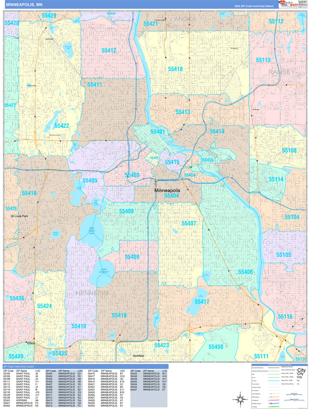
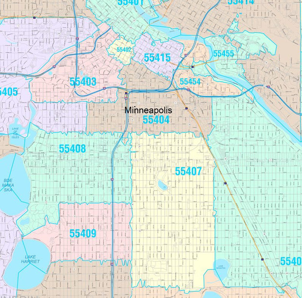
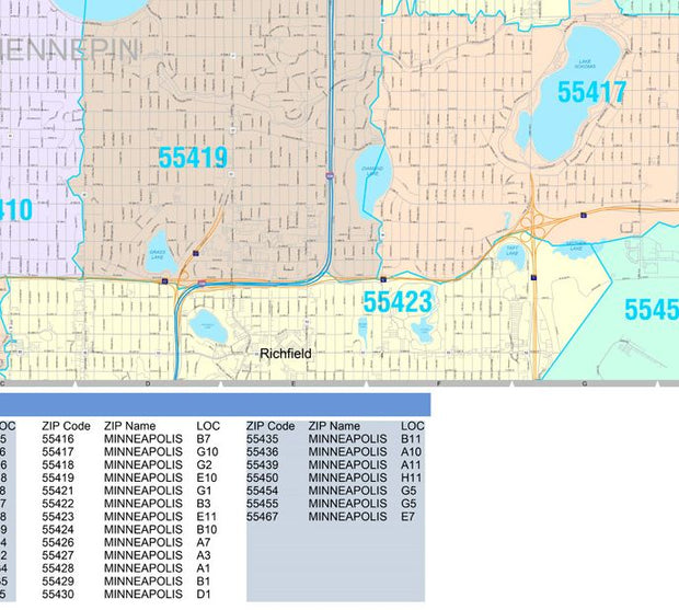
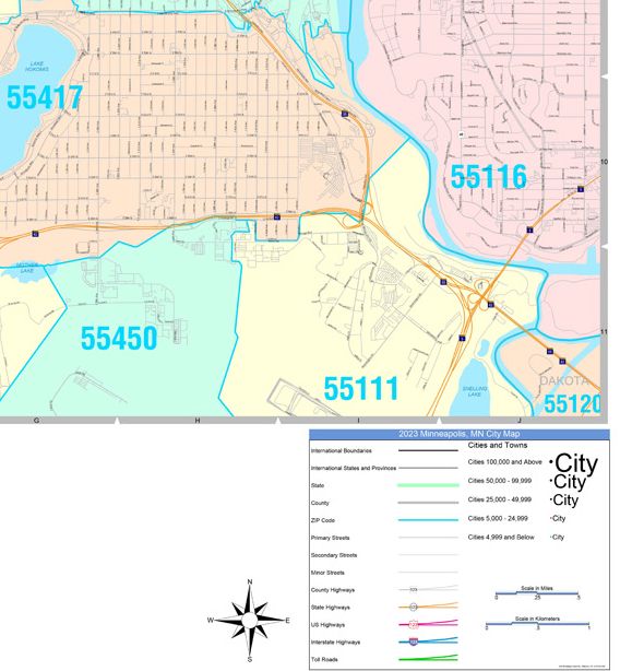
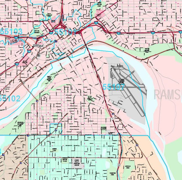
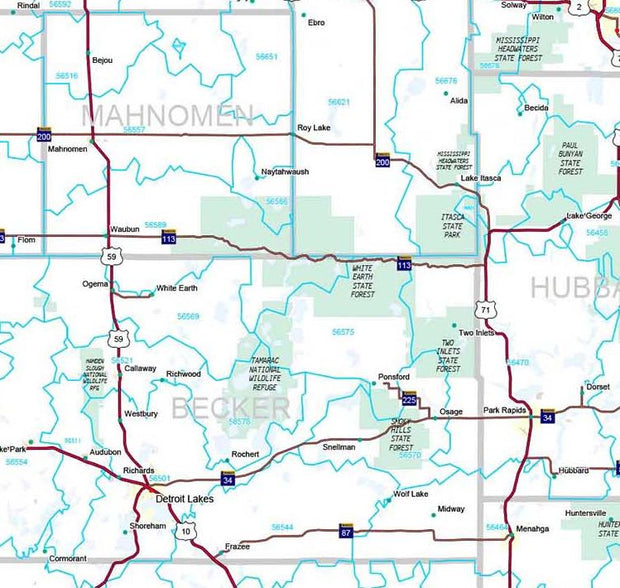
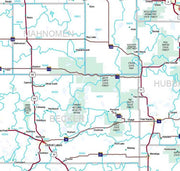
      • Map details include federal, state, and county highways, county boundaries, cities and towns, major waterways, state/national parks, campsites, exit numbers, rest areas, military installations, airports, golf courses, universities, and much more. 

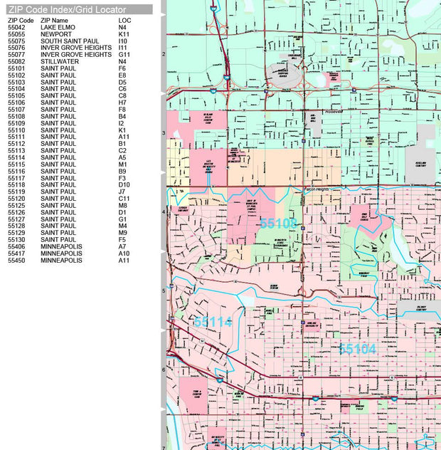
      • You will also find a city/county index on the map, a comprehensive map legend, a distance chart with mileages between various cities, and a mileage/driving times map. 

      • This truly complete wall map even includes a hanging kit with rails for easy mounting just about anywhere. 

      Coverage Area 

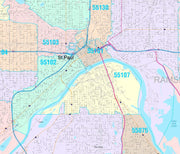
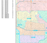
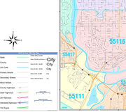
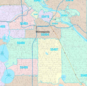
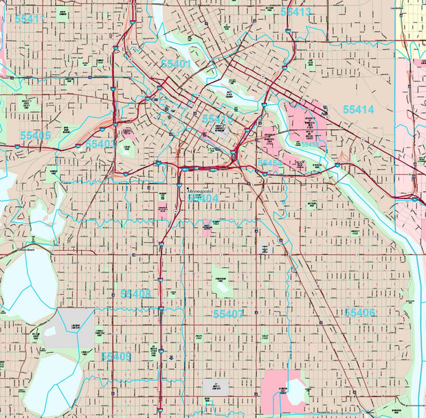
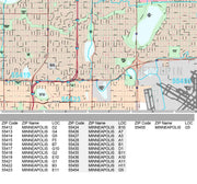
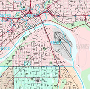
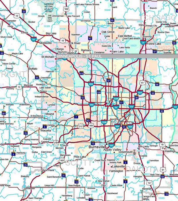
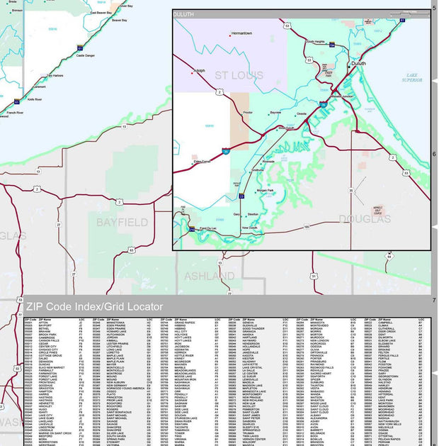
      Inset maps: Duluth/Superior, WI, Fargo, ND/Moorhead, Grand Forks, ND, Mankato, Mesabi Iron Range Region, Rochester, St. Cloud, The Twin Cities: Minneapolis/St. Paul Vicinity, Central Minneapolis, Central St. Paul, and Voyageurs National Park. 

      This map is rolled and shipped in a sturdy cardboard tube.

      Powered by Shopify

      Main menu

      • Home
      • Choose A State
      • Choose A Category
      • Helpful Info

      More Stuff Here

      • Custom Maps
      • Purchase Orders
      • Search for Product
      • Shipping
      • Refunds & returns
      • Contact Us

      Join AMS Newsletter

      Sign-up for Discounts, Coupons, New Product Arrivals and Recent News.

      Powered by Shopify

      • american express
      • apple pay
      • diners club
      • discover
      • google pay
      • master
      • paypal
      • visa

      All of our maps have a Free Shipping Option!