Premium Style Wall Map of North Las Vegas, NV. by Market Maps
NVWM105-1
Regular price
$118.75
Save money on our full line of wall maps from one of the industry leaders in wall maps. These always up to date, eye catching wall maps come in a variety of sizes and finishing options sure to meet your specific mapping needs.
Features include:
Interstate/Us/State Highways
5-Digit ZIP Codes
County Names and boundaries
Cities and Towns as applicable
All water
Institutions
Cemetery
Airports
Golf Courses
Parks
Populated Places Shaded
ZIP Code index with grid locator
Note: Major streets & highways available in all sizes. All streets & highways only available in larger sizes and will show unavailable in smaller sizes.
This map is rolled and shipped in a sturdy cardboard tube.
Rand McNally's state wall map of Nevada is ideal for anyone needing a comprehensive representation of the area for planning, routing, or reference. It isan excellent choice for business and sales strategy, urban development, social work outreach, education, and marketing. State residents, businesses, and government offices are sure to find this wonderful reference tool irreplaceable.
The laminated wall map is printed with UV-resistant ink to help prevent color fading.
Map details includefederal, state, and county highways, county boundaries, cities and towns, major waterways, state/national parks, campsites, exit numbers, rest areas, military installations, airports, golf courses, universities, and much more.
You will also find a city/county index on the map, a comprehensive map legend, a distance chart with mileagesbetween various cities, anda mileage/driving times map.
This truly complete wall map even includes a hanging kit with rails for easy mounting just about anywhere.
Coverage Area
Inset maps:Carson City, Great Basin National Park, Lake Meade National Recreation Area, Lake Tahoe Region, Las Vegas, Las Vegas Strip, Laughlin, and Reno.
This map is rolled and shipped in a sturdy cardboard tube.
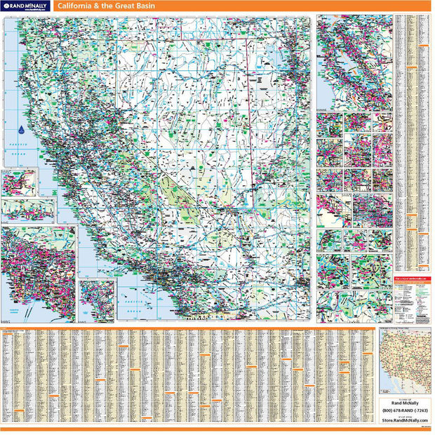
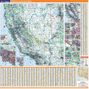
California & the Great Basin by Rand McNally
CAWM001
Regular price
$229.00
Laminated with Hanging Rails
60" W x 60" H
Index of Counties and Cities
Fully Indexed Counties, Cities, Mileage Chart
Inset Maps of All Major Cities
Coverage area includes all of California & Nevada and parts of AZ, CO, UT, ID, OR
Free Shipping!
This map is rolled and shipped in a sturdy cardboard tube.
Nevada State Wall Map
NVWM008
Regular price
$79.95
Wall map of Nevada, showing counties, towns, cities, villages, major roads and highways. Includes community index.
This map comes in a variety of sizes and finishing options. It is shipped rolled in a sturdy cardboard tube.
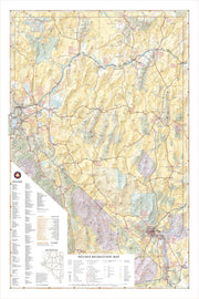
Nevada Recreation Map by Benchmark Maps
1 review
NVWM006
Regular price
$69.95
Nevada’s desert landscapes can seem desolate, but there are world-class recreation oases throughout including Great Basin National Park, Lake Tahoe, Las Vegas, and the Black Rock Desert. This wall map illustrates the diversity of public lands and roadways that make The Silver State a delight for travelers looking for something different.
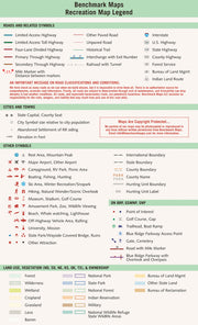
If outdoor adventure and recreation is your thing, this is the map for you. This map is loaded with points of interest from camping sites, hiking trails, fishing spots, and bird watching locations ( see legend shown on 2nd picture) this map depicts all the best recreation locations. Not only functional this exquisite map uses shaded relief to portray the land a technique which combines shading with elevation tints that portray landforms much more clearly than contour lines. These techniques and elevation colors make mountains, highlands and valleys immediately obvious.
Beautiful as well as functional this map will look great in a home, office, cabin, RV or wherever you choose to hang it.
This map is rolled and shipped in a sturdy cardboard tube.
My husband was thrilled with this gift!He can plan his hiking trips with greater clarity and celebrate the places he has been! The quality of the map, the paper, and lamination exceeded my expectations!
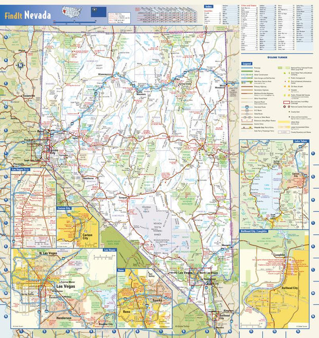
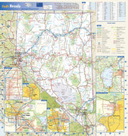
Nevada Wall Map by Globe Turner
NVWM002
Regular price
$69.95
This colorful, easy-to-read state map of Nevada identifies all major thoroughfares, secondary roads, freeway interchanges, rest areas, distance markers, landmarks, recreational areas, and more. Shaded relief on the state map provides a three-dimensional sense of Nevada’s topography. Detailed city inset maps of Carson City, Laughlin, Las Vegas, and Reno are based on the latest street information from our cartographic experts. Additional insets of the Las Vegas Strip and Lake Tahoe depict must-see points of interest in these tourist areas. County and city indices make it simple to locate even the smallest town.
This map is rolled and shipped in a sturdy cardboard tube.