Skip to content
  • Home
  • Choose A State
    • Alabama
    • Alaska
    • Arizona
    • Arkansas
    • California
    • Colorado
    • Connecticut
    • Delaware
    • Florida
    • Georgia
    • Hawaii
    • Idaho
    • Illinois
    • Indiana
    • Iowa
    • Kansas
    • Kentucky
    • Louisiana
    • Maine
    • Maryland
    • Massachusetts
    • Michigan
    • Minnesota
    • Mississippi
    • Missouri
    • Montana
    • Nebraska
    • Nevada
    • New Hampshire
    • New Jersey
    • New Mexico
    • New York
    • North Carolina
    • North Dakota
    • Ohio
    • Oklahoma
    • Oregon
    • Pennsylvania
    • Rhode Island
    • South Carolina
    • South Dakota
    • Tennessee
    • Texas
    • Utah
    • Vermont
    • Virginia
    • Washington
    • Washington, DC
    • West Virginia
    • Wisconsin
    • Wyoming
    • USA Maps
  • Choose A Category
    • US Regional Maps
    • USA Maps
    • Educational Maps
      • US, World & Continents Combo Pull Down Maps
    • Topographic Maps
      • Any USA Topographic Map
      • Alabama Topographic Maps
      • Arizona Topographic Maps
      • Arkansas Topographic Maps
      • California Topographic Maps
      • Colorado Topographic Maps
      • Delaware Topographic Maps
      • Florida Topographic Maps
      • Georgia Topographic Maps
      • Hawaii Topographic Maps
      • Idaho Topographic Maps
      • Illinois Topographic Maps
      • Indiana Topogrpahic Maps
      • Iowa Topographic Maps
      • Kansas Topographic Maps
      • Kentucky Topographic Maps
      • Louisiana Topographic Maps
      • Maine Topographic Maps
      • Maryland Topographic Maps
      • Massachusetts Topographic Maps
      • Michigan Topographic Maps
      • Minnesota Topographic Maps
      • Mississippi Topographic Maps
      • Missouri Topographic Maps
      • Montana Topographic Maps
      • Nebraska Topographic Maps
      • Nevada Topographic Maps
      • New Hampshire Topographic Maps
      • New Jersey Topographic Maps
      • New Mexico Topographic Maps
      • New York Topographic Maps
      • North Carolina Topographic Maps
      • North Dakota Topographic Maps
      • Ohio Topographic Maps
      • Oklahoma Topographic Maps
      • Oregon Topographic Maps
      • Pennsylvania Topographic Maps
      • Rhode Island Topographic Maps
      • South Carolina Topographic Maps
      • South Dakota Topographic Maps
      • Tennessee Topographic Maps
      • Texas Topographic Maps
      • Utah Topographic Maps
      • Vermont Topographic Maps
      • Virginia Topographic Maps
      • Washington Topographic Maps
      • West Virginia Topographic Maps
      • Wisconsin Topographic Maps
      • Wyoming Topographic Maps
    • World Wall Maps
    • International Maps
    • War Maps
  • Helpful Info
    • Our Printing Process
    • Shipping
    • Returns
    • Purchase Orders
    • Custom Maps
  • Log in
Cart
American Map Store American Map Store
Log in Search Cart
Home / Virginia Cities / Virginia: Virginia Cities

Virginia Cities

Virginia Cities

  • View all
  • Revolutionary War
  • Virginia
  • Virginia: Virginia Cities
  • Virginia: Wall Maps
Quick view
Plan of the investment of York and Gloucester, Oct. 1781
$39.95
Quick view
Birds eye view of Alexandria, Virginia by Charles Magnus, 1863
$39.95
Quick view
Carte des environs de Williamsburg en Virginie...Septembre 1781
$39.95
Quick view
Plan of Alexandria, Virginia, 1862
$39.95
Quick view
Norfolk & Portsmouth, Virginia by C. N. Drie, 1873
$39.95
Quick view
Richmond Va Metro Area Wall Map
from $84.95
Quick view
View of the University of Virginia, Charlottesville & Monticello..., 1856
$39.95
Quick view
Perspective map of the city of Roanoke, Virginia by American Publishing Co., 1891
$39.95
Quick view
Perspective map of Newport News, Virginia by American Publishing Co., 1891
$39.95
Quick view
Virginia State Wall Map
from $129.95
Quick view
Perspective map of Bedford City, Virginia, by H. Wellge, 1891
$39.95
Quick view
Birds eye view of Suffolk, Virginia by T. M. Fowler, 1907
$39.95
Quick view
Birds eye view of Franklin, Virginia by T. M. Fowler, 1907
$39.95
Plan of the investment of York and Gloucester, Oct. 1781

Plan of the investment of York and Gloucester, Oct. 1781

VA00004

Regular price $39.95

Plan of the investment of York and Gloucester, Oct. 1781
This beautiful antique map reproduction is printed on heavy acid-free stock with fade proof inks and is excellent for framing.

24"W x 33"H

Birds eye view of Alexandria, Virginia by Charles Magnus, 1863

Birds eye view of Alexandria, Virginia by Charles Magnus, 1863

VA00013

Regular price $39.95

Birds eye view of Alexandria, Virginia by Charles Magnus, 1863
This beautiful antique map reproduction is printed on heavy acid-free stock with fade proof inks and is excellent for framing.

27"W x 18"H

Carte des environs de Williamsburg en Virginie...Septembre 1781

Carte des environs de Williamsburg en Virginie...Septembre 1781

VA00006

Regular price $39.95

Carte des environs de Williamsburg en Virginie...Septembre 1781
This beautiful antique map reproduction is printed on heavy acid-free stock with fade proof inks and is excellent for framing.

33"W x 24"H

Plan of Alexandria, Virginia, 1862

Plan of Alexandria, Virginia, 1862

VA00029

Regular price $39.95

Plan of Alexandria, Virginia, 1862
This beautiful antique map reproduction is printed on heavy acid-free stock with fade proof inks and is excellent for framing.

21"W x 16"H

Norfolk & Portsmouth, Virginia by C. N. Drie, 1873

Norfolk & Portsmouth, Virginia by C. N. Drie, 1873

VA00023

Regular price $39.95

Norfolk & Portsmouth, Virginia by C. N. Drie, 1873
This beautiful antique map reproduction is printed on heavy acid-free stock with fade proof inks and is excellent for framing.

34"W x 22"H

Richmond Va Metro Area Wall Map

Richmond Va Metro Area Wall Map

VAWM106

Regular price $84.95
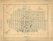
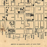
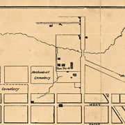
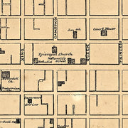
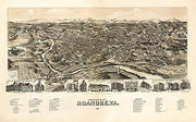
Our Richmond Metro Area wall map shows the area within 15 miles of downtown Richmond, including the communities of Tuckahoe, Mechanicsville, Midlothian, Petersburg, Brandermill, Meadowbrook, Short Pump, Glen Allen, Ashland, and Highland Springs, among others. Features shown include cities, towns, counties, highways and major and secondary roads, zip codes, and major points of interest. Note: due to the vast extent of this map, local street names are not shown. 

This map comes in a variety of sizes and finishing options. It is shipped rolled in a sturdy cardboard tube.

View of the University of Virginia, Charlottesville & Monticello..., 1856

View of the University of Virginia, Charlottesville & Monticello..., 1856

VA00011

Regular price $39.95

View of the University of Virginia, Charlottesville & Monticello..., 1856
This beautiful antique map reproduction is printed on heavy acid-free stock with fade proof inks and is excellent for framing.

24"W x 18"H

Perspective map of the city of Roanoke, Virginia by American Publishing Co., 1891

Perspective map of the city of Roanoke, Virginia by American Publishing Co., 1891

VA00025

Regular price $39.95

Perspective map of the city of Roanoke, Virginia by American Publishing Co., 1891
This beautiful antique map reproduction is printed on heavy acid-free stock with fade proof inks and is excellent for framing.

32"W x 20"H

Perspective map of Newport News, Virginia by American Publishing Co., 1891

Perspective map of Newport News, Virginia by American Publishing Co., 1891

VA00022

Regular price $39.95

Perspective map of Newport News, Virginia by American Publishing Co., 1891
This beautiful antique map reproduction is printed on heavy acid-free stock with fade proof inks and is excellent for framing.

28"W x 18"H

Virginia State Wall Map

Virginia State Wall Map

VAWM005

Regular price $129.95
Wall map of Virginia, showing counties, towns, cities, villages, major roads and highways. A community index is included. 

This map comes in a variety of sizes and finishing options. It is shipped rolled in a sturdy cardboard tube.

Perspective map of Bedford City, Virginia, by H. Wellge, 1891

Perspective map of Bedford City, Virginia, by H. Wellge, 1891

VA00014

Regular price $39.95

Perspective map of Bedford City, Virginia, by H. Wellge, 1891
This beautiful antique map reproduction is printed on heavy acid-free stock with fade proof inks and is excellent for framing.

26"W x 18"H


Birds eye view of Suffolk, Virginia by T. M. Fowler, 1907

Birds eye view of Suffolk, Virginia by T. M. Fowler, 1907

VA00027

Regular price $39.95

Birds eye view of Suffolk, Virginia by T. M. Fowler, 1907
This beautiful antique map reproduction is printed on heavy acid-free stock with fade proof inks and is excellent for framing.

30"W x 20"H

Birds eye view of Franklin, Virginia by T. M. Fowler, 1907

Birds eye view of Franklin, Virginia by T. M. Fowler, 1907

VA00019

Regular price $39.95

Birds eye view of Franklin, Virginia by T. M. Fowler, 1907
This beautiful antique map reproduction is printed on heavy acid-free stock with fade proof inks and is excellent for framing.

23"W x 18"H

Powered by Shopify

Main menu

  • Home
  • Choose A State
  • Choose A Category
  • Helpful Info

More Stuff Here

  • Custom Maps
  • Purchase Orders
  • Search for Product
  • Shipping
  • Refunds & returns
  • Contact Us

Join AMS Newsletter

Sign-up for Discounts, Coupons, New Product Arrivals and Recent News.

Powered by Shopify

  • american express
  • apple pay
  • diners club
  • discover
  • google pay
  • master
  • paypal
  • visa

All of our maps have a Free Shipping Option!